
ovember 9, 2025 | Manila, Philippines
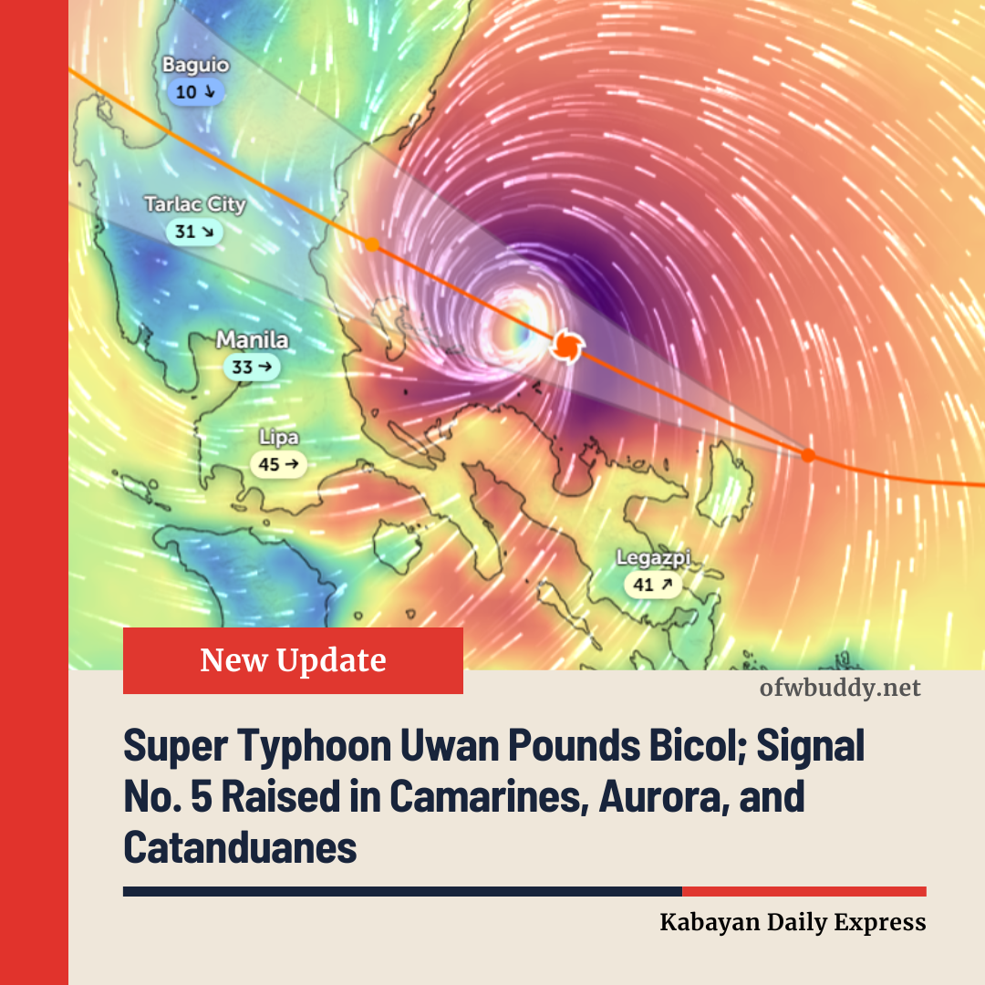
The Philippine Atmospheric, Geophysical and Astronomical Services Administration (PAGASA) issued Tropical Cyclone Bulletin No. 11 on Sunday, warning that Super Typhoon Uwan (Fung-Wong) continues to batter the Bicol Region with life-threatening winds, torrential rains, and dangerous storm surges as it moves west-northwestward over the coastal waters of Camarines Norte.
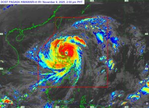
As of 1:00 PM, the eye of Super Typhoon Uwan was located 135 km north-northwest of Virac, Catanduanes, or 100 km northeast of Daet, Camarines Norte (14.7°N, 123.7°E), based on data from the Baler and Daet Doppler weather radars.
The system maintains maximum sustained winds of 185 km/h near the center, gustiness up to 230 km/h, and a central pressure of 935 hPa, moving west-northwestward at 30 km/h.
⚠️ Signal No. 5 Raised in Several Provinces
Tropical Cyclone Wind Signal No. 5 remains in effect in areas facing extreme threat to life and property due to typhoon-force winds exceeding 185 km/h.
Affected areas include:
-
Polillo Islands
-
Northern and eastern parts of Camarines Norte and Camarines Sur
-
Northern portion of Catanduanes
-
Central Aurora
-
Southeastern Nueva Vizcaya and southern Quirino
PAGASA warns residents that extreme damage to structures, power lines, and vegetation is expected. Flying debris and uprooted trees pose a serious hazard to safety.
⚠️ Signal No. 4 and 3 Cover Central Luzon and Metro Manila
Signal No. 4 remains up in parts of Isabela, Quirino, Nueva Vizcaya, Aurora, Nueva Ecija, Quezon, and Bicol, while Signal No. 3 now covers Metro Manila, Central Luzon, CALABARZON, and Northern Samar.
Under these conditions, storm-force winds (89–117 km/h) may cause significant damage to light and medium structures. PAGASA warns that widespread power outages and falling trees are possible in these regions.
🌊 Coastal and Flooding Hazards
A high risk of life-threatening storm surges exceeding 3.0 meters is expected in low-lying coastal areas of Cagayan, Isabela, Pangasinan, Aurora, Zambales, Bataan, Bulacan, Metro Manila, Cavite, Batangas, Quezon, Camarines Norte, Camarines Sur, Catanduanes, Albay, Sorsogon, and Northern Samar.
A Gale Warning is also in effect across most of Luzon and the Visayas, where seas may reach up to 14 meters, making sea travel extremely dangerous for all vessels.
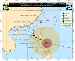
🌀 Track and Landfall Outlook
PAGASA forecasts that Super Typhoon Uwan will continue moving west-northwestward, likely passing close to Calaguas and Polillo Islands this afternoon or evening before making landfall over central Aurora province late tonight or early Monday.
After landfall, Uwan will cross the mountainous terrain of Northern Luzon, significantly weakening but remaining a typhoon as it moves toward the Lingayen Gulf or La Union by Monday morning.
By Tuesday (November 11), Uwan will turn northward, heading toward the Taiwan Strait, and is expected to make landfall in western Taiwan by Thursday (November 13) before rapidly weakening.
🚨 Public Advisory
PAGASA strongly urges residents, especially those in coastal and mountainous areas, to evacuate immediately if advised by local officials. People are warned against venturing outdoors as flying debris and flash floods may occur.
Authorities and disaster risk reduction offices are directed to take all precautionary measures to protect lives and property.
The next Tropical Cyclone Bulletin (No. 12) will be issued at 5:00 PM today.
For the latest updates, refer to official advisories via PAGASA’s website and social media channels.