
Philippines – November 8, 2025, 5:00 PM
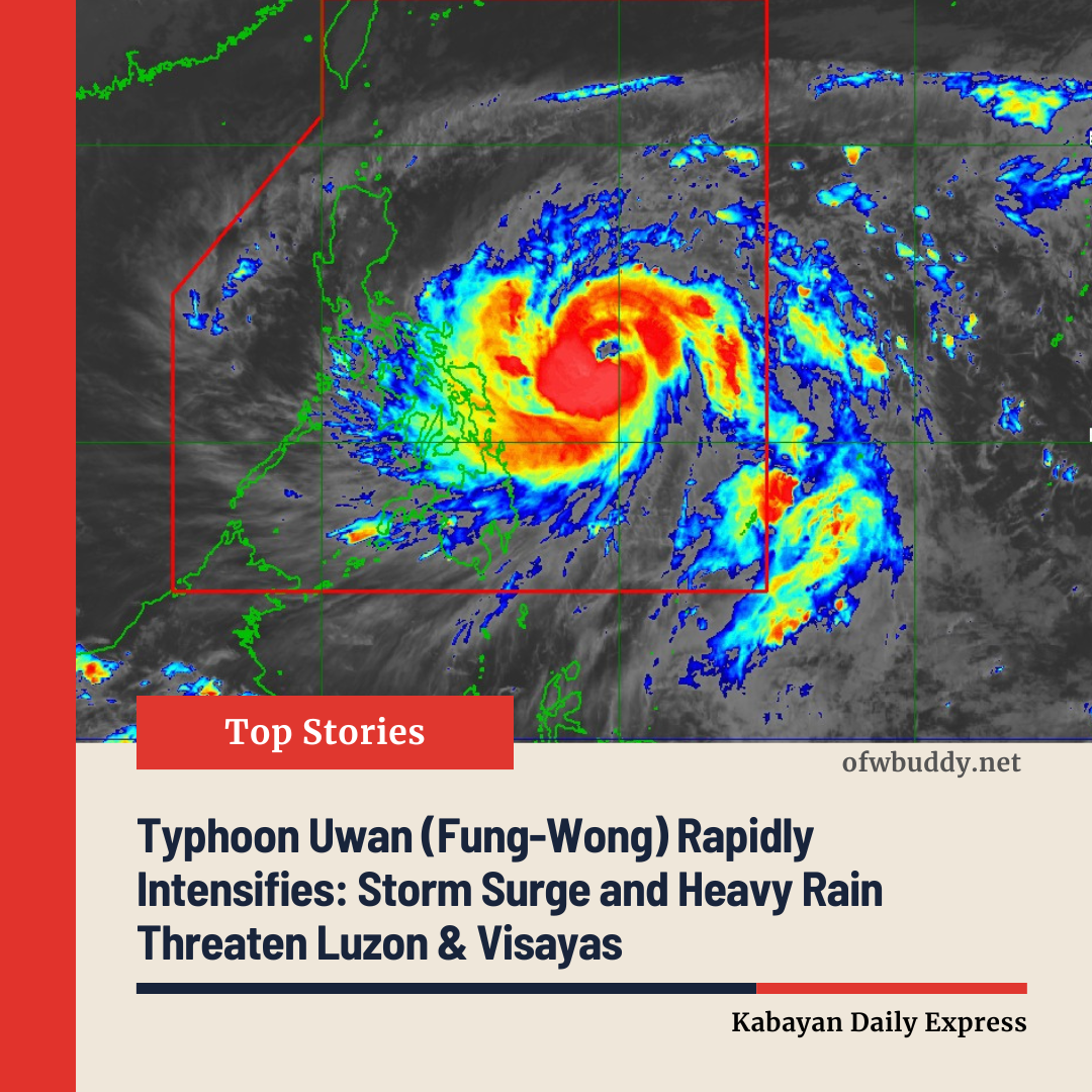
Typhoon Uwan, locally known as Fung-Wong, continues to rapidly strengthen as it moves west-northwest over the Philippine Sea, approaching the Bicol Region and Eastern Visayas. The storm is forecast to bring strong winds, heavy rainfall, and potentially life-threatening storm surges to affected areas.
Current Status (As of 4:00 PM)
-
Location: 575 km east of Catarman, Northern Samar; 620 km east of Virac, Catanduanes (12.9°N, 129.9°E)
-
Intensity: Maximum sustained winds of 150 km/h near the center, gusts up to 185 km/h, central pressure 955 hPa
-
Movement: West-northwest at 30 km/h
-
Wind Radius: Typhoon-force winds extending up to 800 km from the center
Tropical Cyclone Wind Signals in Effect
TCWS No. 3 – Storm-force Winds (89–117 km/h)
Moderate to significant threat to life and property
-
Luzon: Catanduanes, eastern Camarines Sur, eastern Albay, northeastern Sorsogon
-
Visayas: Northeastern Northern Samar
TCWS No. 2 – Gale-force Winds (62–88 km/h)
Minor to moderate threat to life and property
-
Luzon: Cagayan, Isabela, Quirino, Nueva Vizcaya, Aurora, Metro Manila, Rizal, Laguna, Quezon, Marinduque, Camarines Norte, rest of Camarines Sur, rest of Albay, rest of Sorsogon, Burias and Ticao Islands
-
Visayas: Northern and parts of Samar, northern Eastern Samar
TCWS No. 1 – Strong Winds (39–61 km/h)
Minimal to minor threat to life and property
-
Luzon: Batanes, rest of Cagayan, Apayao, Abra, Kalinga, Mountain Province, Ifugao, Benguet, Ilocos Norte and Sur, La Union, Pangasinan, Tarlac, Pampanga, Zambales, Bataan, Cavite, Batangas, Masbate, Romblon, Oriental and Occidental Mindoro, Calamian and Cuyo Islands
-
Visayas: Samar, Eastern Samar, Biliran, Leyte, Southern Leyte, Bohol, northern and central Cebu, northern Negros Occidental and Oriental, Guimaras, Iloilo, Capiz, Aklan, Antique
-
Mindanao: Dinagat Islands, Surigao del Norte, northern Agusan del Norte, northern Surigao del Sur
Other Hazards
-
Heavy Rainfall: Refer to Weather Advisory No. 7 for flooding-prone areas.
-
Coastal Flooding: High risk of storm surges exceeding 3.0 meters in low-lying areas of Luzon, Visayas, and parts of Mindanao.
-
Sea Conditions: Gale warnings issued; waves up to 14 meters expected in northern and eastern seaboards of Luzon. Mariners are advised to remain in port.
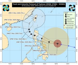
Forecast and Track
-
Typhoon Uwan is expected to pass close to Catanduanes tomorrow morning and may make landfall in southern Isabela or northern Aurora by tomorrow evening or early Monday.
-
Rapid intensification could push the typhoon to super typhoon strength, with the potential for landfall at or near its peak intensity.
-
After crossing Northern Luzon, the storm will weaken over mountainous terrain but is expected to remain a typhoon as it moves over the West Philippine Sea.
Authorities urge residents in high-risk areas to follow evacuation orders and take all necessary precautions to protect life and property. Continuous monitoring of PAGASA advisories is strongly recommended.
The next tropical cyclone bulletin will be issued at 11:00 PM today.
Source: DOST-PAGASA