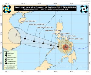
November 4, 2025 – 11:00 AM | DOST-PAGASA Bulletin No. 14
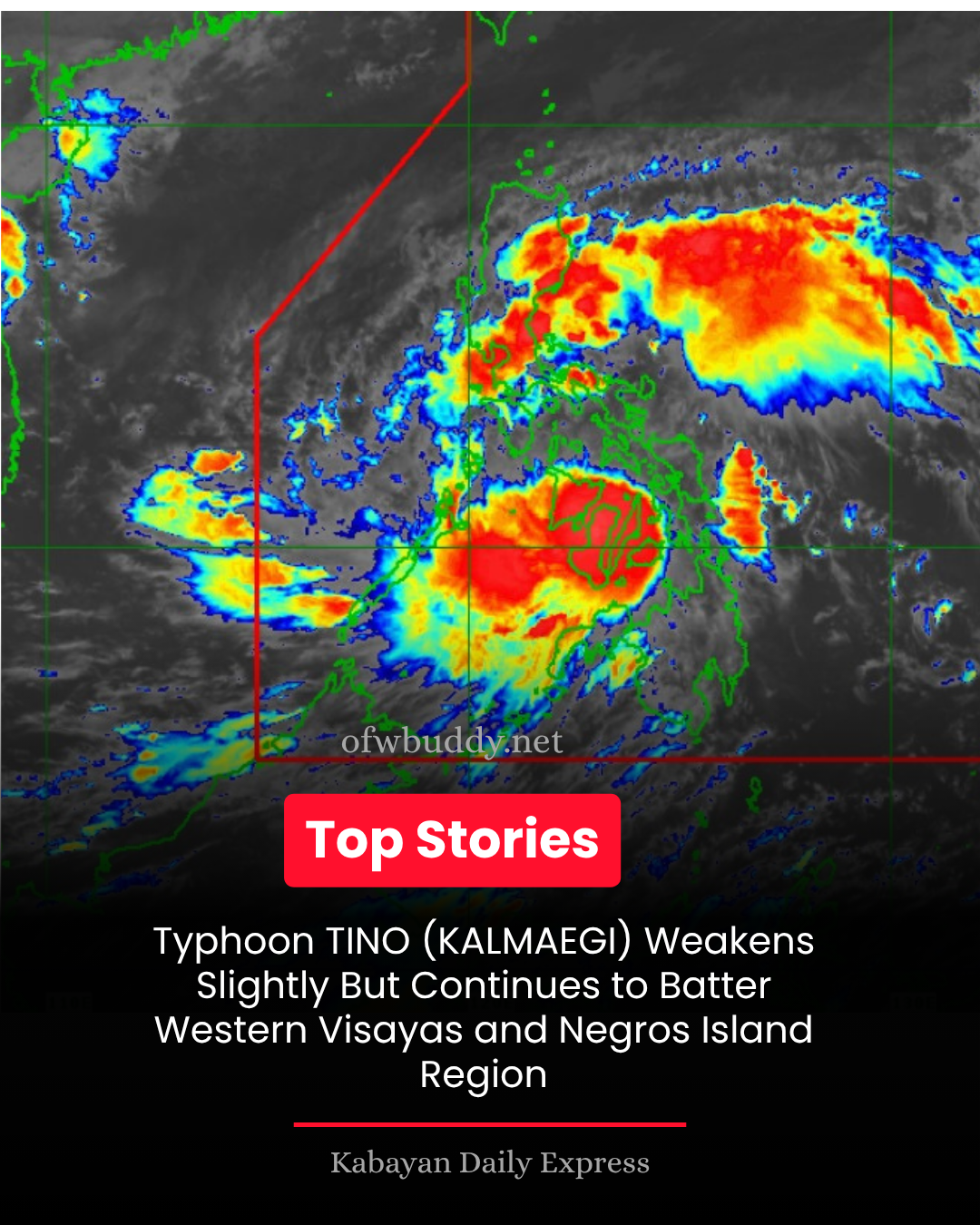
BACOLOD CITY, Philippines — Typhoon TINO (international name KALMAEGI) continues to threaten Western Visayas and the Negros Island Region as it moves westward, bringing destructive winds, torrential rains, and dangerous storm surges across affected provinces.
According to the Philippine Atmospheric, Geophysical and Astronomical Services Administration (PAGASA), the eye of TINO was located at 10:00 AM near Bacolod City, Negros Occidental (10.6°N, 122.9°E). The typhoon carries maximum sustained winds of 140 km/h near the center, gusts of up to 195 km/h, and a central pressure of 965 hPa, moving west at 25 km/h.
🌪️ Areas Under Tropical Cyclone Wind Signals
Signal No. 4 — Typhoon-force winds (118–184 km/h)
Significant to severe threat to life and property over:
-
Cuyo Islands, northern Negros Occidental, northern Negros Oriental, Guimaras, Capiz, Iloilo, and parts of Antique and Aklan.
Signal No. 3 — Storm-force winds (89–117 km/h)
Moderate to significant threat over:
-
Northern Cebu, Bantayan Islands, northern Negros Oriental, northern Negros Occidental, Aklan, Antique, Calamian Islands, El Nido, and parts of Masbate and Palawan.
Signal No. 2 — Gale-force winds (62–88 km/h)
Minor to moderate threat across:
-
Southern Mindoro, Romblon, Cebu, Bohol, Leyte, Negros Oriental, and northern Palawan.
Signal No. 1 — Strong winds (39–61 km/h)
Minimal to minor threat over:
-
Quezon, Marinduque, Mindoro provinces, Masbate, Sorsogon, Albay, Palawan, Samar, Leyte, Bohol, and Siquijor.
🌧️ Heavy Rainfall and Wind Impacts
PAGASA warned of heavy to intense rainfall across the Visayas, MIMAROPA, and Bicol Region, likely causing flooding and landslides, especially in low-lying and mountainous areas.
Strong winds will persist in areas under TCWS Nos. 3 and 4, while gusty conditions due to the enhanced Northeast Monsoon will also affect Metro Manila, CALABARZON, Central Luzon, and parts of Mindanao.
🌊 Storm Surge and Coastal Hazards
Coastal areas across Masbate, Romblon, Mindoro, Palawan, Western Visayas, Negros Island, and Central Visayas are under high risk of life-threatening storm surges exceeding 3 meters within the next 24 hours.
A Gale Warning remains in effect for most Luzon, Visayas, and Mindanao seaboards. Seas are forecast to be very rough to high, with waves reaching 6 meters in some areas. PAGASA strongly advises all mariners and small vessels to remain in port until conditions improve.
🌀 Forecast Track and Outlook
Typhoon TINO is expected to cross Western Visayas and northern Palawan before emerging over the West Philippine Sea by Wednesday morning (November 5). While it may slightly weaken due to land interaction, it is projected to remain a typhoon and may re-intensify once it moves back over open waters.
The public, especially residents in high-risk flood and landslide zones, are urged to stay alert and comply with evacuation orders from local disaster management offices.
PAGASA emphasizes that TINO’s track may still shift within the forecast cone, and its impacts may be felt beyond the landfall area.
The next tropical cyclone bulletin will be issued at 2:00 PM today.