
October 17, 2025 — Manila, Philippines
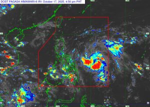
The Philippine Atmospheric, Geophysical and Astronomical Services Administration (PAGASA) reported that Tropical Depression “Ramil” continues to maintain its strength while moving west-southwestward over the Philippine Sea, potentially affecting Bicol Region and Eastern Visayas within the next 24 hours.
As of 4:00 PM today, the center of Ramil was located 640 kilometers east of Juban, Sorsogon (12.8°N, 129.9°E) with maximum sustained winds of 55 km/h, gustiness reaching 70 km/h, and a central pressure of 1002 hPa. It is currently moving west-southwestward at 25 km/h, with strong winds extending up to 400 kilometers from its center.
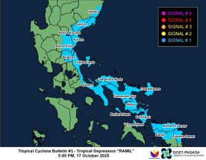
Areas Under Tropical Cyclone Wind Signal (TCWS) No. 1
Residents in the following areas are advised to brace for strong winds (39–61 km/h) that may cause minimal to minor damage to life and property:
Luzon:
-
Southeastern Isabela (Dinapigue)
-
Eastern and southern Quirino (Maddela, Nagtipunan)
-
Southeastern Nueva Vizcaya (Alfonso Castañeda)
-
Aurora, eastern Nueva Ecija, eastern Bulacan
-
Northern and eastern Quezon (including Polillo Islands)
-
Camarines Norte, Camarines Sur, Catanduanes, Albay, Sorsogon, Burias Island, and Ticao Island
Visayas:
-
Northern Samar
-
Northern portion of Eastern Samar (San Policarpo, Arteche, Oras, Dolores, Maslog, Jipapad, Taft, Can-Avid)
-
Northern Samar (Matuguinao, San Jose de Buan, Calbayog City, Gandara, Santa Margarita, Pagsanghan, San Jorge)
Weather Outlook and Hazards
Rainfall and Flooding:
PAGASA warns of heavy rainfall in areas affected by Ramil’s outer rainbands and trough. Flooding and landslides are possible, especially in low-lying and mountainous areas.
Strong Winds:
Stronger winds may be felt in coastal and elevated areas. The highest possible alert level during Ramil’s passage is Signal No. 2, though intensification into a severe tropical storm before landfall is possible.
Coastal Inundation:
A minimal to moderate storm surge (1.0 to 2.0 meters) may affect coastal areas of Isabela, Aurora, Quezon, Camarines Norte and Sur, Catanduanes, Albay, Sorsogon, Northern Samar, Eastern Samar, and Samar within 48 hours.
Sea Conditions:
Rough to very rough seas (up to 4.0 meters) are expected along the northern and eastern seaboards of Catanduanes, Camarines Sur, and Northern Samar. PAGASA advised small fishing boats and motorbancas not to venture out to sea.
Forecast Track
According to PAGASA, Ramil will move generally westward over the next 24 hours before turning west-northwestward toward Central and Southern Luzon. The tropical depression is forecast to make landfall over Catanduanes by Saturday afternoon (October 18), then move across Bicol Region in the evening. It may make another landfall over Aurora or Quezon on Sunday morning (October 19) before exiting into the West Philippine Sea by Monday (October 20).
The system is expected to intensify into a tropical storm within 12 hours and could become a severe tropical storm prior to landfall.
Public Advisory
PAGASA urged the public, especially residents in high-risk areas, to take precautionary measures, follow local evacuation orders, and stay tuned for updates from local disaster risk reduction offices.
The next tropical cyclone bulletin for Tropical Depression Ramil will be issued at 8:00 PM today.