
📅 November 9, 2025 | 5:00 PM Update
📍 Manila, Philippines
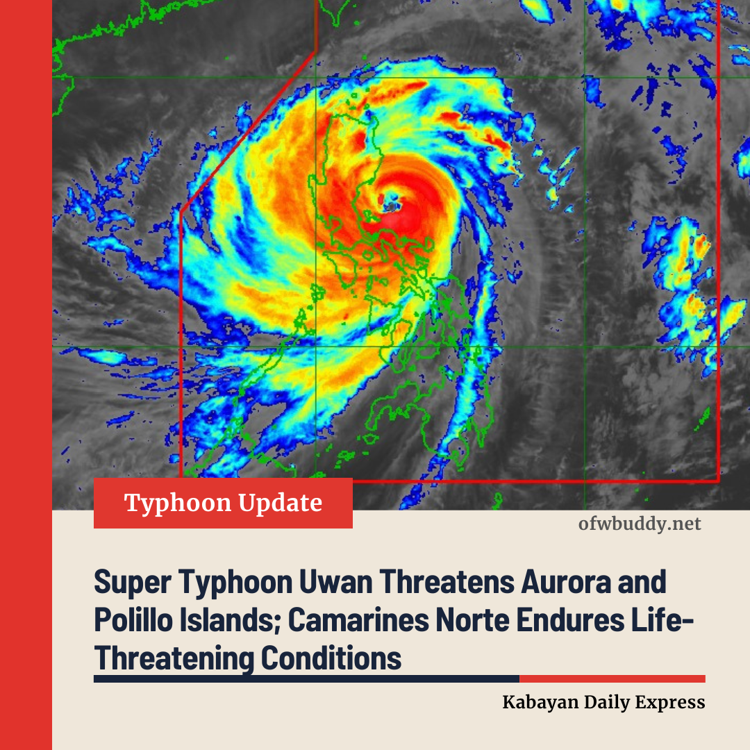
Super Typhoon Uwan (international name: Fung-wong) continues to unleash life-threatening conditions across Camarines Norte, as the massive weather system moves west-northwest toward Aurora and Polillo Islands, according to the Philippine Atmospheric, Geophysical and Astronomical Services Administration (PAGASA).
As of 4:00 PM, the center of Uwan’s eye was estimated at 110 km north of Daet, Camarines Norte, or 150 km east-northeast of Infanta, Quezon (15.1°N, 123.0°E). The super typhoon is packing maximum sustained winds of 185 km/h, gusts of up to 230 km/h, and a central pressure of 935 hPa, moving west-northwest at 30 km/h.
PAGASA said Uwan’s powerful winds extend outward up to 900 kilometers from its center, affecting a vast portion of Luzon.
⚠️ Areas Under Tropical Cyclone Wind Signals (TCWS)
-
Signal No. 5 (Extreme Threat)
Covers parts of Aurora, Polillo Islands, northern Camarines Norte, and nearby areas, where winds may exceed 185 km/h, posing an extreme threat to life and property. -
Signal No. 4 (Severe Threat)
Includes portions of Isabela, Nueva Vizcaya, Quirino, Nueva Ecija, Benguet, La Union, Pangasinan, and Camarines Sur, among others. Winds in these areas range from 118 to 184 km/h, capable of causing significant damage. -
Signal No. 3 (Moderate to Significant Threat)
Now hoisted over Metro Manila, Cavite, Batangas, Laguna, Rizal, Zambales, Pampanga, and parts of Northern Samar. Storm-force winds between 89 to 117 km/h are expected. -
Signal Nos. 2 and 1
Cover the rest of Luzon, Visayas, and parts of Mindanao, where gale-force and strong winds may still cause minor to moderate damage.

🌧️ Heavy Rainfall and Coastal Hazards
PAGASA warned of torrential rains, damaging winds, and dangerous storm surges reaching over 3 meters along coastal communities in Cagayan Valley, Central Luzon, Metro Manila, CALABARZON, Bicol Region, and parts of Visayas and Mindanao within the next 48 hours.
A Gale Warning remains in effect over nearly all seaboards of Luzon, Visayas, and eastern Mindanao, with sea heights ranging from 7 to 14 meters, making sea travel extremely dangerous.
🌀 Track and Intensity Outlook
PAGASA forecasts Uwan to continue moving west-northwestward, passing close to Polillo Islands before potentially making landfall over Aurora province tonight or early tomorrow (Nov. 10).
Due to its massive eyewall, a direct hit over Calaguas and Polillo Islands is likely even without landfall. The system is expected to weaken slightly after crossing the mountainous terrain of Northern Luzon but remain a typhoon as it exits toward the Lingayen Gulf by Monday morning.
By Tuesday (Nov. 11), Uwan is forecast to turn northward, then northeastward, heading toward Taiwan by Wednesday or Thursday, where it may make landfall and weaken rapidly.
📢 Public Advisory
PAGASA and disaster officials urge residents in high-risk areas—particularly those in coastal, low-lying, and mountainous communities—to evacuate immediately if advised by local authorities. The public is reminded not to focus solely on the storm’s center track, as Uwan’s wide circulation can bring severe weather far from its core.
The next bulletin will be issued at 8:00 PM today.
🌊 Key Facts:
-
Maximum winds: 185 km/h
-
Gusts: Up to 230 km/h
-
Movement: West-northwest at 30 km/h
-
Areas affected: Central and Northern Luzon, including Metro Manila