

November 9, 2025 | Manila, Philippines
The Philippine Atmospheric, Geophysical and Astronomical Services Administration (PAGASA) has announced that Typhoon Uwan (international name: Fung-Wong) has intensified into a Super Typhoon, unleashing life-threatening winds and torrential rains across Catanduanes and nearby provinces early Sunday morning.
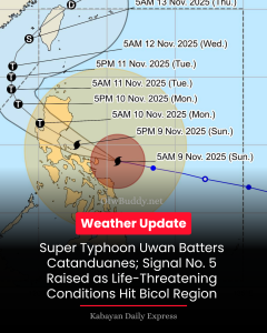
As of 7:00 AM, the center of Super Typhoon Uwan was estimated at 125 km east-northeast of Virac, Catanduanes (14.0°N, 125.3°E). The system is packing maximum sustained winds of 185 km/h near the center, gustiness of up to 230 km/h, and a central pressure of 935 hPa, moving west northwestward at 25 km/h.
⚠️ Signal No. 5 Up in Catanduanes, Parts of Camarines Provinces, and Polillo Islands
PAGASA raised Tropical Cyclone Wind Signal (TCWS) No. 5 — the highest warning level — over the following areas:
-
Catanduanes
-
Polillo Islands
-
Northern Camarines Norte (including Daet and Paracale)
-
Eastern Camarines Sur (including Caramoan, Garchitorena, Tinambac, and Lagonoy)
These areas are now experiencing extreme winds and dangerous conditions, posing an extreme threat to life and property.
⚠️ Signal No. 4 in Quezon, Camarines, and Albay
TCWS No. 4 remains in effect over the eastern portion of Quezon, the rest of Camarines Norte and Camarines Sur, and parts of Albay, where typhoon-force winds may cause severe damage.
⚠️ Metro Manila Now Under Signal No. 3
The capital region, Metro Manila, along with Central Luzon, CALABARZON, and portions of Northern Samar, are under Signal No. 3, as storm-force winds and intense rains are expected within the next 18 hours.
🌧️ Heavy Rainfall and Storm Surge Threat
According to PAGASA, life-threatening storm surges exceeding 3.0 meters may hit low-lying and coastal areas of Cagayan, Isabela, Pangasinan, Aurora, Zambales, Bataan, Bulacan, Metro Manila, Cavite, Batangas, Quezon, Camarines Norte, Camarines Sur, Catanduanes, Albay, Sorsogon, Northern Samar, and Eastern Samar.
Authorities warn residents in flood-prone and landslide-susceptible areas to evacuate immediately and follow the directives of local disaster management offices.
🌊 Dangerous Sea Conditions
A Gale Warning is in effect for nearly all seaboards of Luzon, Visayas, and Mindanao, with wave heights reaching up to 14 meters in some coastal areas. PAGASA warns that sea travel remains extremely dangerous, especially for small vessels.
🌀 Projected Track
PAGASA forecasts that Super Typhoon Uwan will pass close to Catanduanes this morning, possibly making landfall over Aurora by tonight or early Monday. The storm may hit land at or near peak intensity, before weakening as it crosses Northern Luzon and exits via Lingayen Gulf or La Union by Monday morning.
By Tuesday (November 11), Uwan is expected to move northwestward, exit the Philippine Area of Responsibility (PAR), and re-enter near Taiwan by Thursday, before completely leaving PAR by Friday morning.
PAGASA strongly urges the public to remain alert, stay indoors, and monitor official updates through local government units and the agency’s social media channels.
The next tropical cyclone bulletin (No. 10) will be issued at 11:00 AM today.