
November 9, 2025 | Manila, Philippines
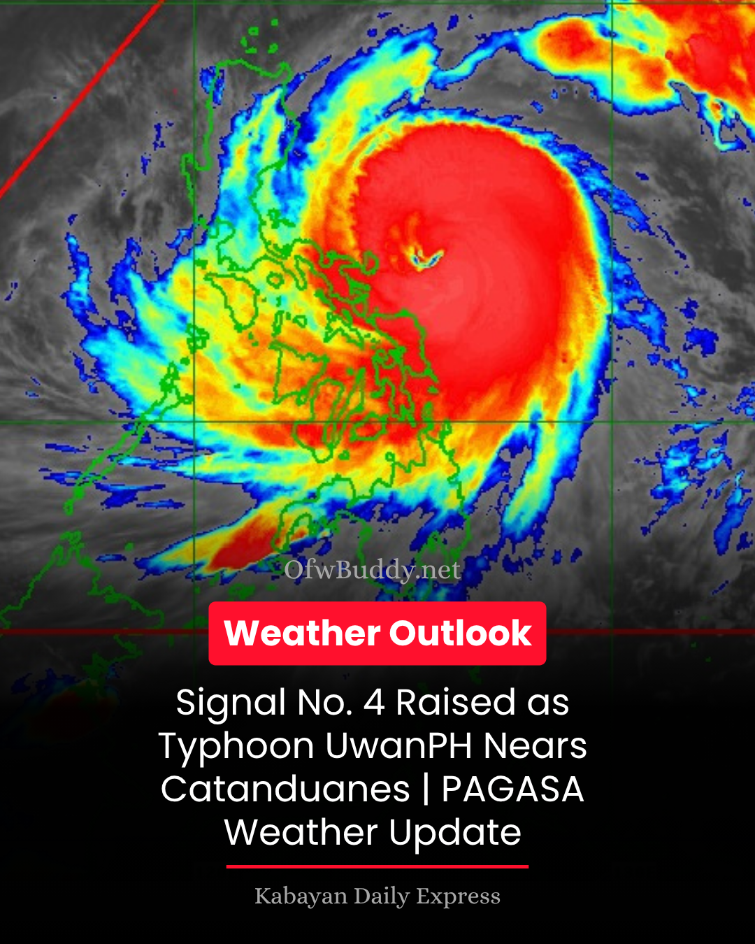
The Philippine Atmospheric, Geophysical and Astronomical Services Administration (PAGASA) reported early Sunday morning that Typhoon Uwan (international name: Fung-wong) continues to rapidly intensify as it moves closer to Catanduanes, posing a significant threat to several regions in Luzon and parts of the Visayas.
As of 4:00 AM, the eye of Typhoon Uwan was located 195 kilometers east of Virac, Catanduanes (13.8°N, 126.0°E). The system carries maximum sustained winds of 175 km/h near its center, gustiness reaching up to 215 km/h, and a central pressure of 940 hPa. It is moving west-northwest at 35 km/h, with typhoon-force winds extending up to 800 kilometers from its center.
⚠️ Tropical Cyclone Wind Signals in Effect
-
Signal No. 4: Typhoon-force winds (118–184 km/h) pose a severe threat to life and property in Polillo Islands, Catanduanes, eastern Camarines Norte and Camarines Sur, and eastern Albay.
-
Signal No. 3: Storm-force winds threaten Metro Manila, Calabarzon, Central Luzon, parts of Ilocos, Cagayan Valley, Bicol, and Northern Samar.
-
Signal No. 2 and No. 1: Gale- to strong-force winds are expected in parts of Visayas and Mindanao, including Leyte, Bohol, Cebu, Negros, Dinagat Islands, and Surigao provinces.
🌧️ Heavy Rainfall and Flooding Threat
PAGASA warns that heavy to torrential rains will affect Bicol Region, Northern Samar, Aurora, and Quezon, possibly triggering flash floods and landslides, especially in mountainous and low-lying areas. The combined effects of Typhoon Uwan’s outer rainbands and the northeast monsoon will enhance rainfall across Luzon and Visayas in the coming days.
🌊 Storm Surge and Coastal Flooding
A life-threatening storm surge exceeding 3 meters is expected within the next 48 hours along the coastal areas of Cagayan, Isabela, Pangasinan, Zambales, Bataan, Metro Manila, Batangas, Quezon, Bicol Region, and Northern Samar. PAGASA urges residents in coastal and flood-prone zones to move to higher ground and follow local evacuation orders.
🌬️ Gale Warnings and Rough Seas
Mariners are strongly advised not to venture out to sea, as very rough to high seas (up to 14 meters) are expected across the seaboards of Northern and Central Luzon, the eastern seaboards of Visayas, and Mindanao. Even small seacraft operators are urged to stay in port until conditions improve.
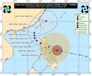
🌀 Forecast Track and Intensity
According to PAGASA, Typhoon Uwan is projected to pass close to Catanduanes this morning before making landfall over Aurora tonight or early Monday morning. It is forecast to reach super typhoon category before landfall. After crossing Northern Luzon’s mountainous terrain, it is expected to weaken but remain a typhoon as it exits via Lingayen Gulf or La Union by Monday morning.
The public and local disaster risk reduction offices are advised to take all necessary precautionary measures, secure property, and stay alert for further bulletins. Those in high-risk areas are urged to evacuate immediately if advised by authorities.
The next tropical cyclone bulletin for Typhoon Uwan (#UwanPH) will be issued by PAGASA at 8:00 AM today.