
🌪️ PAGASA Weather Update: Severe Tropical Storm “TINO” Nears Typhoon Category — Eastern Visayas and Northern Mindanao Under Signal No. 3
Issued by DOST-PAGASA | November 3, 2025 – 8:00 AM
Next update: 11:00 AM
#TinoPH #Kalmaegi #WeatherAdvisory #PAGASAUpdate #PhilippineWeather
⚠️ Severe Tropical Storm “TINO” Intensifies, Approaching Typhoon Strength
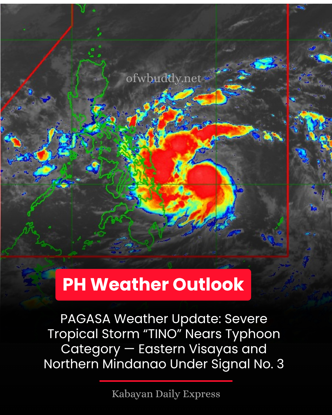
The Philippine Atmospheric, Geophysical, and Astronomical Services Administration (PAGASA) reports that Severe Tropical Storm “TINO” (international name: Kalmaegi) continues to strengthen as it moves west-southwestward, now nearing typhoon intensity.
As of 7:00 AM, the storm’s center was estimated at 360 km east of Guiuan, Eastern Samar (10.6°N, 129.0°E) with maximum sustained winds of 110 km/h, gustiness up to 135 km/h, and central pressure of 980 hPa. It is moving west-southwest at 25 km/h, bringing a wide swath of strong to storm-force winds extending up to 300 km from the center.
🌬️ Areas Under Tropical Cyclone Wind Signals (TCWS)
Signal No. 3 (Storm-force winds)
-
Visayas: Southeastern Eastern Samar (Guiuan, Mercedes)
-
Mindanao: Dinagat Islands, Siargao, and Bucas Grande Islands
💨 Expected wind speeds: 89–117 km/h
⚠️ Impacts: Moderate to significant damage to structures, trees, and power lines.
Signal No. 2 (Gale-force winds)
-
Visayas: Central and southern parts of Eastern Samar, Samar, Leyte, Biliran, Southern Leyte, Bohol, northern and central Cebu (including Bantayan and Camotes Islands), and northeastern Negros Occidental.
-
Mindanao: Surigao del Norte (rest of the province), northern Surigao del Sur, and northeastern Agusan del Norte.
💨 Expected wind speeds: 62–88 km/h
⚠️ Impacts: Minor to moderate threat to life and property.
Signal No. 1 (Strong winds)
-
Luzon: Sorsogon, Masbate (including Ticao and Burias Islands), Albay, Romblon, Mindoro provinces, parts of Quezon, Marinduque, and Palawan (including Cuyo and Calamian Islands).
-
Visayas: Northern Samar, rest of Eastern Samar and Samar, Siquijor, Negros Oriental, Iloilo, Capiz, Aklan, Antique.
-
Mindanao: Surigao del Sur, Agusan provinces, Misamis Oriental, Camiguin, and northern Bukidnon.
💨 Expected wind speeds: 39–61 km/h
⚠️ Impacts: Minimal to minor damage possible.
🌧️ Rainfall and Flooding Threats
According to PAGASA’s Weather Advisory No. 7, both the Shear Line and Tropical Storm TINO will bring heavy to intense rains over parts of the Visayas and Mindanao.
Residents in low-lying and mountainous areas are urged to prepare for flooding and rain-induced landslides.
👉 Full advisory: tinyurl.com/wxadvisory
🌊 Storm Surge and Coastal Flooding Warning
A storm surge exceeding 3 meters may affect Sorsogon, Masbate, Romblon, Mindoro, Palawan, Visayas, Dinagat Islands, Surigao provinces, Agusan del Norte, Misamis Oriental, and Camiguin within 48 hours.
Coastal residents should evacuate immediately or move to higher ground.
🚢 Gale Warning and Sea Conditions
-
Eastern seaboards of Visayas and Mindanao, and southern Luzon coasts are under Gale Warning No. 2.
-
Waves may reach up to 9 meters in height in Eastern Samar, Leyte, and Dinagat waters.
-
All types of vessels, especially small boats and motorbancas, are advised not to venture out to sea due to dangerous conditions.
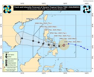
🌀 Forecast Track and Intensity
“TINO” is expected to intensify into a typhoon within 12 hours and could reach super typhoon strength before landfall.
📍 Landfall likely over Southern Eastern Samar, Leyte, Southern Leyte, or Dinagat Islands between midnight and early morning of November 4.
It will then move across Visayas and northern Palawan, exiting to the West Philippine Sea by November 5.
📣 Public Advisory
PAGASA reminds all residents and Disaster Risk Reduction and Management Offices (DRRMOs) in affected regions to:
-
Follow local evacuation orders.
-
Stay tuned to the next bulletin at 11:00 AM.
-
Monitor advisories from local PAGASA regional offices and LGUs for real-time updates.
Stay safe and alert!
For updates, visit the official PAGASA website or follow trusted weather channels.