
November 11, 2025
Typhoon Fung-wong is making its presence felt across Taiwan today, with Yilan County recording more than 500 millimeters of rainfall in the past 24 hours, reaching “extremely heavy rain” levels. The Central Weather Bureau (CWB) updated its forecast at 11:30 AM, noting a slight delay in the typhoon’s approach to the island.
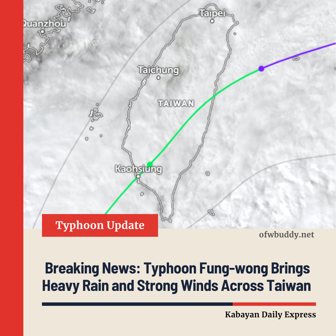
The storm is expected to make landfall in southern Taiwan—specifically in South Kaohsiung and Pingtung—early Wednesday morning. Current forecasts indicate that Pingtung is the most likely landfall location. The typhoon is projected to move offshore from Taitung by Thursday morning. As it nears Taiwan, central and southern regions should prepare for heavy rain and strong winds, while the southwest coast should remain alert for storm surges.
According to the CWB at 11:00 AM, the typhoon’s storm circle is gradually moving into southwestern Taiwanese waters. Rain warnings remain in effect for Yilan County, while land warnings are active for Tainan, Kaohsiung, Pingtung, Taitung, and the Hengchun Peninsula. Sea warnings continue for the Taiwan Strait, southeastern waters, the Bashi Channel, and areas around Dongsha Island.
Typhoon Path and Forecast
Forecaster Chu Mei-lin explained that Fung-wong has shifted slightly north and west over the past few hours, prompting a minor southward revision in its projected path and a delay in its arrival time. The storm is expected to make landfall in Kaohsiung and Pingtung between Wednesday morning and evening, before moving out to sea from Taitung on Thursday morning. While forecasts remain uncertain, authorities continue to monitor the storm closely for any sudden changes.
Rainfall and Flood Risk
Chu Mei-lin highlighted that the combined effects of the typhoon will significantly impact northern and eastern Taiwan today. Green Island has received over 350 mm of rain, classified as torrential, while Yilan has surpassed 500 mm, reaching extremely torrential levels. As of 11:00 AM, cumulative rainfall totals include 119 mm in New Taipei City, 156.5 mm in Hualien, and 125 mm in Taitung.
From 2 PM today to 2 PM tomorrow, rainfall is expected to slightly decrease in northern and eastern Taiwan, but heavy rain will continue in the Greater Taipei area, eastern regions, and mountainous areas of Pingtung. Additional heavy rain is expected in western mountainous zones, the plains of Yilan, the Hengchun Peninsula, Keelung, and Taipei plains. Central and southern Taiwan will see increasing rainfall from tonight, with brief periods of intense rain as the typhoon’s center approaches on Wednesday.
Wind and Wave Alerts
Coastal and open areas should prepare for strong gusts ranging from Force 9 to 11 on the Beaufort scale. From today until 6:00 AM tomorrow, northern coastal areas, Taoyuan, Keelung, Matsu, and Penghu may experience gusts up to Force 10. Strong winds are also expected along western coasts and inland plains. Wave heights near Taiwan could reach 3 to 5 meters, while southwestern coasts, Taitung, the Hengchun Peninsula, and Penghu may see waves of 5 to 6 meters. Authorities advise avoiding all beach activities.
Current Status of Typhoon Fung-wong
As of 11:00 AM today, Typhoon Fung-wong is classified as a tropical storm, located approximately 350 kilometers southwest of Eluanbi. It is moving north-northeast toward Taiwan at 11–14 km/h. Maximum sustained winds near the center are 30 meters per second (equivalent to Force 11), with gusts reaching 38 meters per second (Force 13). The storm’s gale-force winds extend 220 kilometers for Force 7 winds and 60 kilometers for Force 10 winds.
From midnight on November 10 to 11:00 AM today, the CWB reported rainfall totals as follows: Ximaoshan in Yilan County – 612.5 mm, Niutoushan in Taitung County – 396.5 mm, Dachukeng in New Taipei City – 309.5 mm, Taian in Hualien County – 298 mm, Qingtiangang in Taipei City – 269 mm, and Binlang in Pingtung County – 227 mm. Lanyu Island experienced Force 12 gusts, while Hengchun, Dongji Island, Xinwu, and Pengjia Island recorded Force 10 gusts.
Authorities continue to urge residents in affected areas to stay indoors, avoid non-essential travel, and closely monitor updates from the Central Weather Bureau.